City of Edinburgh Council publishes Seafield neighbourhood masterplan

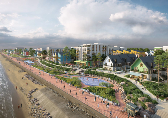
A masterplan to transform Seafield in north-east Edinburgh into a new environmentally friendly neighbourhood, connecting its coastline to the surrounding communities in Leith, Portobello and Craigentinny, was published yesterday by the City of Edinburgh Council.
Currently, the area is primarily made up of car showrooms, trades, light industry as well as Lothian Buses’ Marine Depot and the Council’s Seafield Household Waste Recycling Centre. The draft ‘Seafield Place Brief’ and ‘Draft Seafield Masterplan’ have been produced to add detail to the allocation in the Council’s local development plan, City Plan 2030, as one of 44 pieces of land across Edinburgh allocated as an ‘Opportunity Site’ for development.
Planning convener Councillor James Dalgleish said: “Our draft plan focuses on the creation of a new environmentally friendly neighbourhood at Seafield to help address the city’s housing emergency.
“Options for higher density flats, with the clear aim of 35% of homes on site being affordable, are being explored with stunning views across the Firth of Forth alongside excellent community facilities. We’re estimating the site could potentially deliver as many as 2,700 homes with a range of other styles of housing such as colonies and townhouses. We’ll also make sure there are opportunities for employment and community uses.
“Our bold vision to transform this area would open up the Seafield section of Edinburgh’s coastline creating an attractive and seamless promenade linking to the waterfront communities that already exist on either side. I’d like to thank the local people and businesses whose views have helped get us to this stage and I look forward to receiving further feedback from the upcoming consultation to help us finalise our plans.”
A new primary school, GP surgery and plenty of green space are also proposed for Seafield as well as a Waterfront Park. Improved public transport, walking, cycling and wheeling routes linking to the wider area are also included. The provision of a heat network to help the city with its net zero target is planned. This would also help to keep utility bills down for future residents.
The area under consideration stretches from Seafield Street in the north to King’s Road in the south. The eastern boundary of the site is the Forth Estuary, while the western boundary is defined by a railway line and by Seafield Recreation Area. Seafield Road East, part of the A199, runs through much of the site. As Seafield is a coastal area, work is also ongoing with the Scottish Environment Protection Agency to make sure we mitigate against any future flood risk.
If approved for consultation by the Planning Committee next week, residents, businesses and other organisations interested in the area will be asked to give their views on the ‘Draft Seafield Place Brief’ and ‘Draft Seafield Masterplan’, developed following extensive consultation with local people and businesses.


